|
Facts and Maps
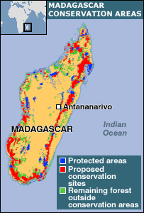
Madagascar is the 4th largest island in the world. It lies off the southeastern coast of Africa near Mozambique. The people speak Malagasy which has 18 dialects and is somewhat originated from French. The highest point on the island is over 9,000 feet. It is one of the poorest countries in the world. The capital is Antananarivo. We will be visiting the southwest Toliara region of Madagascar.
Here are links to maps showing all kinds of information about Madagascar. These will help you learn about where Madagascar is, about the land, conservation, animal habitats, where the people live and much more.
|
|

 Hotel Victory (Google Earth KMZ)